Table of Contents
Wifi based positioning
Thanks to our IT and telecommunications tools today, we use their location services on a daily basis. The best known positioning system is GPS. In the GPS system, the location of our device (mobile phone, computer, tracking device, etc.) is determined using satellites. The basis of this is the communication and data supply between our device and the satellites - on the other hand, it is a condition that our device “sees” the satellites, there must be no extinguishing medium between them.
GPS-based positioning does not work in buildings, underground garages, tunnels, because the walls, ground layers and other landmarks prevent the said “view” of the satellites. For example, a carrier may take the device you want to track down to the subway and cover several kilometers without realizing it.
Before we go into the different solutions, let’s take a brief look at the basics.
Location methods
The purpose of positioning is to determine the geographical position, or coordinates, of a thing. Perhaps the more widely known, old method of triangulation is to determine the fourth place using three already known points.
If we know the coordinates of a point and its distance from our device ® and draw a circle of radius around that point, our device will be somewhere in that arc.
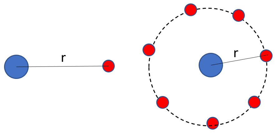
Since the arc consists of an infinite number of points and our device can be on any of them, we didn’t get much closer to locating it. We can significantly reduce the number of possible positions if we have two known points - then there are only two options left.

The final solution requires three known points, our device is located at the intersection of the three circular arcs.

Specific mathematical calculations are not covered, but the coordinates of the three known points and the coordinates of the device can already be calculated.
From the point of view of our topic, however, it is questionable to know and determine the distances ®. Surveyors calculate the distance between two points so that one of them is at one point with a protractor and the other with a rod at the other point.

Knowing the height of the rod (h) and the angle of view (α), the distance can be calculated. However, this method is not applicable here, since in case of GPS, it is not possible to stand next to the satellites with a rod. The solution, now greatly simplified, is based on measuring radio waves: the satellite emits radio waves, our device captures them and, knowing the speed of the wave propagation, calculates its distance from the satellite. Applying this to additional satellites, we finally get the required distances (the coordinates of the satellites are known).
Methods using Wi-Fi
But what reference points can we rely on if we are in a building and can't see the satellites? One option is to use wifi networks.
Today, there is a wifi network almost everywhere (residential buildings, institutions, metro, airport, etc.). Our devices (telephone, computer, tracking device) are connected to the network access points (APs). Physically, these access points are routers. Routers also emit radio waves - these are received by our devices. E.g. if in our apartment we look at the list of available networks on our phone or computer, then approx. you can see the following:

The list includes the wifi access points (routers) that we are within range of (one of which is obviously ours that we are currently connected to). We can also see how strongly the signals from each router reach us: the signals from more distant ones are obviously weaker, those from closer ones are stronger. And that may be the key: if we know the distance-dependent “attenuation” coefficient of wifi waves, we can calculate how far we are from a particular router. Based on multiple routers, we get more reference points and distances - and if we knew the coordinates of the routers, we could already calculate the geographical position of our device.
Here, however, we run into another problem: while satellites coordinates are known (because the they communicate them), they are not available on wifi routers. Of course, there are several possible solutions - let’s look at one of them.
Suppose we are standing next to buildings on the street. There are several routers in the buildings, some of which even reach us. Our device receives these signals (see the picture above). If we pre-register the routers (with their type-specific waveforms and coordinates), we could create a list of the router coordinates whose signals we will receive without any further calculations. By choosing the strongest of these, we can say that this router e.g. we are within 30 meters. Thus, knowing the coordinates of the router, we shot our positions with an accuracy of 30 meters. Not bad, but not good enough.

We can further refine this by knowing that the propagation of radio waves can be affected by various landmarks. So the router with the strongest signal may not be the closest to us - an other one may be the half distance away, but a concrete wall and / or a crowd of people standing in line between us (the human body is one of the strongest shielding media!). If our device forms an “average router” from the data of the routers detected in its environment, it will probably be even more accurate to determine our position - in today's practice, this means an accuracy of less than 5 meters.
We can say that the weak point of the method is the registration of routers. Who is it that tracks all the routers in the world (including the one in our room) and stores these data? Well, Google, for example. As they continuously track all of the world’s road networks and their changes to run their map, or photograph routes for their street view service, routers are regularly mapped and data is stored in a database. Yes, yours, in the corner of the room, is on their records. And if this registry exists, all you have to do is look up the nearby routers detected by your computer, phone or tracking device (you don't even have to log in to their wifi network) and you already have the coordinates.
For those who are susceptible to others constantly peeking into their bedrooms, I also have good news: Google can be prevented from registering our router and using it for its location services. All you have to do is configure the router (when naming your network) with the suffix “_nomap” after the SSID, for example: MYNETWORKNAME_nomap.
Summary
Accurate positioning is an important requirement in our lives today. Of course, sometimes we feel like we’re trapped in networks, but when we get lost on the roads or have to get to an unknown place quickly, or maybe a kid is lost at Tesco, it’s good to have location services and the networks and records that allow them on hand. There are many such services and methods, of which we have now looked at Wi-Fi-based solutions - far from the need for completeness in terms of how the solutions are needed, but rather focusing on the possibility itself.
Tracking easily and efficiently


